
As most of you know, the Northwest Passage has been in the sights of explorers and traders for literally centuries. The dream has always been to find a shorter route from Europe to Asia than going all the way around Africa or all the way around South America. Even today, with the Suez Canal (ouch) and the Panama Canal cutting off thousands of miles, being able to take cargo ships and freighters between Asian and European markets over a northern route would save considerable time and money if only it were a real possibility.
Thanks to man-made climate change, the loss of permanent sea ice is having a devastating impact on the people and animals that have lived in the Arctic for millennia. Absolutely devastating. But, those same people whose zest for commercial enterprises helped bring us global warming are increasingly seeing that the dream of a navigable Northwest Passage is coming back to life with a vengeance. The big question is whether you see this as a silver lining to the climate crisis or a future nail in the coffin for our planet. Personally, the ramifications for opening up the Arctic sea routes to heavier traffic – and pollution – scare me to death and depress me like hell, but that’s just me.
While looking at these maps of the exploration of the Northwest Passage through history, keep in mind that for most of the year, the parts that look like water in the maps is mostly ice. This first map shows how many tried, over how many centuries (1587-1941). [Click on any map to zoom in on more details.]

This next map provides a clearer description of a representative sampling of explorers’ routes.

This next map, of Amundsen’s The Maud, shows what these voyages were really like: getting marooned in ice jams, not enough food, perishingly cold, and crews dying.

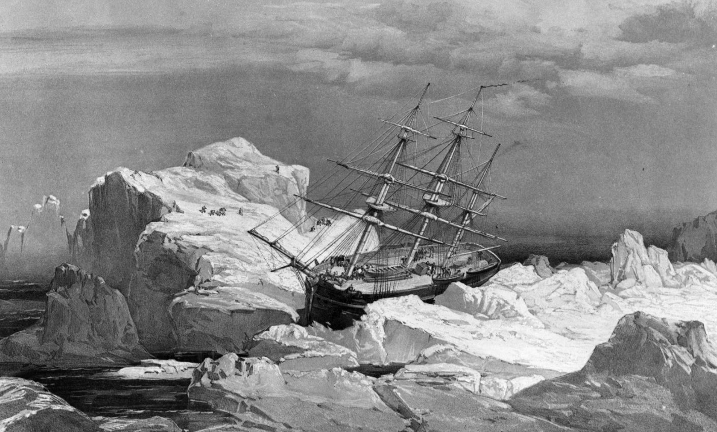
And to make the reality even clearer, this is a drawing of the HMS Investigator – dispatched on the search for the doomed Franklin Expedition. As happened to so many of them, the ship got stranded in ice on the north coast of Baring Island in the Arctic in this 1851 drawing. (National Archives of Canada/The Canadian Press)
Since the advent of powerful modern ships and industrial-strength icebreakers, somewhat more successful voyages have been made, but it has only been since the Arctic sea ice started melting at startling rates in the past 20 years that the glint in people’s eyes has grown.
What kind of difference do the potential new Arctic routes make?
The next map shows the distances between some of the competing routes, and hence the allure of the Arctic routes.

China has claimed that “the Arctic situation now goes beyond its original inter-Arctic States or regional nature.” The Arctic is no longer just a “region.” It’s a situation, and situations demand responses. Furthermore, the Arctic has a vital bearing on “the survival, the development, and the shared future for mankind.” They’ve stated their expectations; take note!
The next map is a little blurry and all in Chinese characters, so will be hard to make out. But have fun figuring out its positioning: Africa is in the lower left, South America is in the upper left, and I think the black line is going from Beijing to Washington, D.C. (or New York). It illustrates the importance of the northern routes to China.

There are a variety of Arctic routes that are opening up due to the reduction of Arctic Ocean ice coverage, some more accessible than others. This next map shows the main routes in use as follows: Red=Northwest Passage, Turquois=Northern Sea Route, Green=Transpolar Sea Route, Purple: Arctic Bridge Route.

This next map shows both recent and current usage of the current major routes, and also future projections. The expectation is for large-scale growth in a very fragile part of the world.

These next maps show how much more feasible Arctic shipping is in summer than in fall, winter, or spring. And this new summer look is only possible because of the changes climate change has already wrought on this part of the world. The thin red lines indicating the much further extent of the summer sea ice as recently as 10 years ago is telling.

A few points to ponder:
- When the Americans, Chinese, and Russians are all looking at supremacy in an ecologically fragile part of the planet, we should pay attention.
- Notice how many of these routes go through northern Canadian waters, which Inuit communities and Arctic animals call home.
- With the opening of these waters, the former U.S. president actually opened Arctic waters off Alaska for the drilling of oil. Let’s hope that is rethought.
- The same three superpowers are vying for access/control of Greenland’s emerging (as the ice cap melts) natural resources. Watch out, Greenlanders!
Some call the Arctic the soul of Canada. That notion wouldn’t resonate with all Canadians, but it does with me. So challenging, so spectacularly beautiful, so special, so deserving of our protection.


Your post resurrected (this day after Easter!) a word from years gone by. Upon reviewing your maps and ample information I can only say “Bummer” as in ‘we humans are such a bummer’. We are literally making the Earth into our own grave and will take many other species with us. Soon it will be too late to wake up.
LikeLiked by 1 person
I know. It’s heartbreaking. Our behaviour towards each other is problematic enough; our behaviour towards the world around us in indefensible in the extreme. And it’s finally caught up with us, from pandemics to extreme weather to fires and floods. And it didn’t have to be this way. 😥
LikeLike
It didn’t. Our arrogance will be our downfall as a species.
LikeLiked by 1 person
I love seeing maps from a different perspective, because of what we see in school you think Finland and Greenland are pretty far away, but they aren’t really.
LikeLiked by 1 person
Awesome. You should enjoy Map Mondays then, sometimes I just show different map projections. You’re right, the standard Mercator projection we see is very misleading.
LikeLike
Reblogged this on Musings and Wonderings and commented:
The thoughts of the US, China & Russia squabbling over the borders on our Northern coasts is truly terrifying. Even more terrifying will be the coming consequences of warming. And if we doubt this just take a look at the weather in Labrador this winter, absolutely stunning! I am truly worried for my grandkids future.
LikeLike
Thanks for this Jane; took me while to understand some of the maps but your interpretation is very clear and chilling…we have not taken care of our home…
LikeLike
Oh, boy! When lots of money is involved, all bets are off. Sigh.
LikeLiked by 1 person
Laurie, you nailed it. It’s always about the money. Sigh indeed.
LikeLike
Alas.
LikeLiked by 1 person
That’s exactly what I was thinking as I was reading this — money was/is paramount and everything else becomes secondary. – Marty
LikeLike
Yup. The greater good takes a back seat every time. At least nearly every time. As one of my old favorites laments (which I’m sure you also know and love, Marty!), “When will they ever learn, when will they ever learn?”
LikeLiked by 1 person
Oh, that sage Pete Seeger. He knew for sure.!
LikeLiked by 1 person
😦
LikeLike
I agree with you, Jane. It is the soul of Canada, and I’m fearful for the future as well.
LikeLiked by 1 person
Thanks, Debra. I sure wish we had more reason for optimism.
LikeLike
Wow Jane. The detail in this post is amazing. I love studying maps (I think I’m strange in that regard). Anyway very interesting topic. Sadly I think it will only be a matter of time before the northwest passage becomes a regular shipping route.
LikeLiked by 1 person
Sadly, I think you’re right, AP2. And I think it is a sin. A crime against our planet, our soul, and the lives and cultures of the Arctic peoples and animals, all in the name of money, as usual.
LikeLiked by 1 person
I am with you — I feel like it is truly threatened and to add shipping lanes to it will be the start of the fastest decline ever seen. It’s one of those things that as a tiny cog in a small speck on earth I feel helpless but as a CBC listener I know that it is directly impacting those communities.
LikeLike
I know, Bernie, I know. People don’t seem to get – or care – that the polar regions are warming at something like 5-6 times the rate of the rest of the world because the northerly air circulation caused by the revolving Earth brings the polluted air from the south. Then when the sea ice is gone, the sun’s rays are no longer reflected from the ice, instead they’re absorbed into the sea. Hence the very rapid changes. The melting that it’s causing is not only resulting in rapid destruction of wildlife and human habitat and hunting ability in the far north, but also will be causing huge rises in sea levels before we know it. Irresponsibility in the name of unbridled capitalism knows no bounds. So profoundly sad.
LikeLike
Pingback: Map Monday: the future of the Arctic with global warming and economic “opportunity” – Polar Red Climate Crisis